Clear-sky UV index and ozone
at a location
UV archive
overview
Clear-sky UV index and ozone
|
UV archive overview |
| UV index forecast maps : Europe | The Netherlands | Dutch Caribbean | World |
|
UV index and ozone at a location
Information on the resolution of the data
|
On the resolution of the UV index dataThe UV index at a location tool returns the forecasts of the UV index and the total ozone column for a user-specified location at local solar noon of today and the coming few days for clear-sky conditions and in the absence of snow.The UV index is computed on a longitude-latitude grid of 0.25 by 0.25 degrees (at the equator this grid measures about 25 kilometers) and subsequently stored at this resolution. The value of the UV index reported for a certain location is thus an average value, valid for the whole grid cell within which the given location lies.
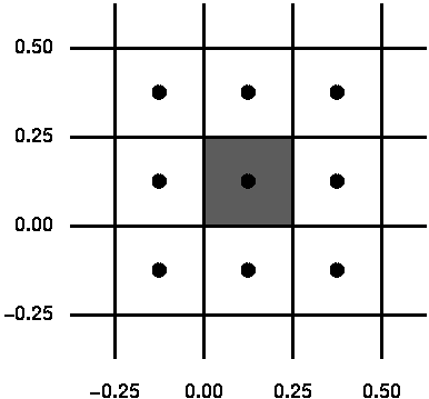
The above plot shows a segment of the longitude-latitude grid. All locations within one grid cell, e.g. the shaded one, receive the same UV index value: no interpolation is performed. It is therefore not necessary to give several decimals for the selected location: one or two will do fine. A single value valid for a whole grid cell is in most cases a good approximation, as the ozone field does not change much along such relative short distances. Differences with the actual UV index value within a single grid cell will be small: 2% for UV index values above 1.0, and less then 0.1 point for UV index values below 1.0. Only when the ground elevation changes much within a single grid cell, such as in mountaines regions, the actual UV index value (which also depends on the altitude) may vary more within a grid cell. If the given longitude value is exactly at a grid cells edge, the grid cell to the left (west) is used. If the given latitude value is exactly at a grid cells edge, the grid cell below (south) is used. This means that the shaded area in the above illustration represents:
    0.00 < longitude <= 0.25
    0.00 < latitude  <= 0.25
Longitude=0.26 gives the grid cell immediately to the right of the
shaded area, and longitude=0.00 gives the grid cell immediately to the
left of the shaded area.
|
![]() last modified: 24 November 2020
last modified: 24 November 2020
data product contact:
Jos van Geffen & Ronald van der A
Copyright © KNMI / TEMIS